It’s like the start of summer. We’re going back to searing June heat with a heavy emphasis on the humidity in the coming days.
Last heat wave was June 28-30 with highs of 97, 99, and 100, respectively. And with all due respect, that was a lil’ hell on Earth for a few days. Heat indices were jacked up well over 100 degrees at times.
And that seems to be the crux of the forecast this go-round. The models’ temp forecast is about the same – hovering in the mid-90s - but the dew points seem to be a little out of hand in some cases.
Get Boston local news, weather forecasts, lifestyle and entertainment stories to your inbox. Sign up for NBC Boston’s newsletters.
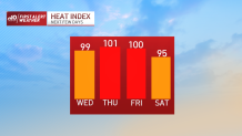
Of course, the heat index is dependent on the amount of humidity in the forecast, so high dew points can correspond to extremely high heat indices.
Suffice it to say, it will feel every bit of 100-104 degrees at the hottest points of Thursday and Friday. If the dew points jump just a little (like close to the upper 70s), then those values may jump to 106-108.
This seems unlikely, however, given the latest information from our guidance – and the fact that we don’t live in southern Florida.
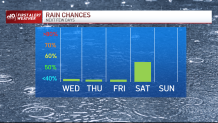
How about storms? With all this heat, you’d think we’d fire up a few. Chances are slim since the air mass is so hot in the mid and upper atmosphere, but there may be one or two stray storms that roam in from western New England late in the day tomorrow or Friday.
Certainly the best chance seems to be Saturday with the approaching front. Timing issues here. The front could scoot through in the early part of the day or towards mid-afternoon. Either way you slice it, there’s more refreshing air moving in by Sunday.
And early next week looks stellar…as long as we can keep the smoke out of the sky. Stay cool!