An end to the excessive heat is in sight. Tuesday will bring another day of 90 degree readings across New England. The spell of heat will be ended as a cold front brings thunderstorms across the region on Tuesday.
Isolated severe storms are possible with damaging winds 60 mph and downpours of rain at times. While widespread totals are generally less than half an inch, a few spouts will see one to two inches with the heaviest of activity.
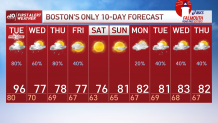
The front doesn’t completely clear the coast until Friday, so both Wednesday and Thursday will carry moderate dewpoints in the 60s, and chances for showers. Temperatures on Wednesday and Thursday are in the upper 70s to low 80s.
Get Boston local news, weather forecasts, lifestyle and entertainment stories to your inbox. Sign up for NBC Boston’s newsletters.
Friday brings a much drier and low humidity day. Temperatures are cooler too with highs near 77°. Warmth and humidity slowly rebuild next week, though as of this moment doesn’t look as excessive as we’ve seen in the past week.