
For a relatively quiet weather day, conditions are varied across New England Monday with lots of clouds hanging tough in southern New England, while sunshine has made a strong appearance from northern Massachusetts and points north.
The course of the day will bring battling sun and clouds for many, but clouds will dominate near and south of the Massachusetts Turnpike, keeping temperatures in the lower to middle 70s while areas with some sun rebound to near and over 80 degrees by afternoon.
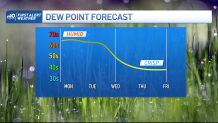
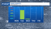
Showers are expected to remain limited after Monday morning’s departure of early rain, though a few new showers will crop up from time to time, particularly south and north – southeastern Massachusetts and in the mountains of the North Country – but none are expected to be substantial. The weak southerly wind developing through Monday night into Tuesday will continue to gradually increase humidity, with dew point temperatures well into the 60s and nearing 70 for a muggy feeling by Tuesday.
Get Boston local news, weather forecasts, lifestyle and entertainment stories to your inbox. Sign up for NBC Boston’s newsletters.
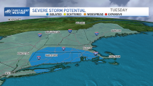
The increasing moisture will mean areas of dense fog overnight Monday night into Tuesday morning, likely to slow the commute for many. New showers will erupt from west to east Tuesday morning, continuing off and on through midday into the afternoon and featuring some thunderstorms thanks to the increasingly moist and warm air as temperatures reach the 70s regionwide.
With a continued influx of moisture at the same time a strong, energetic storm approaches from the Great Lakes, some thunderstorms may grow strong, particularly in western, northern and central New England. With the combination of weather impacts from early fog and then thunderstorms, our weather team has issued a First Alert for Tuesday.
As the wind shifts Tuesday night to blow from the west, the door opens to drier, pleasant air that will come accompanied by sunshine for a splendid Wednesday with high temperatures pushing near 80 degrees, before cooler air arrives incrementally from Wednesday night through Friday.
The air moving into New England for late week delivered isolated frost to northern Minnesota Monday, with morning lows in the 30s, and the valleys of the North Country of New England may see a similar temperature dip overnight Thursday night with very isolated valley frost possible in the Great North Woods of New Hampshire early Friday morning!
With Friday the expected coolest day of the next ten, with daytime highs in the 60s for many and even 50s in the North Country, dry air dominates for days on end for plenty of sunshine from this Wednesday all the way through next weekend, with temperatures fairly quick to rebound back into the 70s to near 80 Saturday and Sunday, respectively.
Weather Stories


Even next week starts on a bright and dry note, with showers not returning to the forecast – at least as of this early view – until the middle of next week.
