A major snowstorm is heading towards New England and will arrive Wednesday between 9 p.m. and midnight across southern New England. This storm continues through Thursday morning and early afternoon, bringing around a foot of accumulation for a lot of areas around the Massachusetts Turnpike on either side.
Cold air continues to build in the meantime. Lows tonight will be in the single digits, teens and 20s north to south. More 20s are in store for the highs on Wednesday, giving the ground ample time to freeze up and accept the new snowfall accumulation.
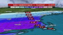
There will be a coastal front that slides in as the low-pressure system passes south of us. This means our temperatures will be very cold north of there, and in the 30s to near 40 southeast. That's why Cape Cod will see only a few inches of snow, compared to Boston where we may see around a foot of snow.
The zone of heaviest snow continues to shift a bit in the forecast models. It shifts a bit farther north of the Pike towards 128 north of Boston. There may be bands of heavy snow, then lower snow totals within the zone of heavy snow with 12-15 inches. So one town may see 10 inches, the other at 15 inches.
Northern New England will see a sharp cutoff in snow too thanks to dry air and very cold temperatures.
Our winds will be gusty from the northeast all night Wednesday into Thursday and peak winds will be 40-50 mph. Not the highest winds we have seen in these storms, but enough to create near blizzard conditions near the coast.
Low visibility, whiteout conditions and blowing and drifting snow will make travel terrible Thursday. The farther northwest you go, the fluffier the consistency. Cape Cod will get the total opposite with more mixing — more of a cement and heavy texture.
Coastal flooding is a threat for Thursday's early afternoon high tide. Minor flooding with shoreline roads getting 1-2 feet of induncation is likely. The promising thing is that this storm doesn't have time to help build our seas too much, unless the low dramatically deepens at the last second and slows down (unlikely). So seas will be 10-15 feet offshore but only for a short time Thursday. Beach erosion will be minor to moderate however.
After this storm, we see cold temperatures Friday and Saturday but keeping it dry. Sunday into Monday and Tuesday a wintry mix is possible.
Temperatures may actually warm to the 40s next week. As we lead into Christmas, there are no major snowstorms but some festive flakes may fly on Christmas Eve and Christmas Day in northwestern New England.