New England is on the precipice of intense heat and humidity, which returns Wednesday through Friday.
Tuesday dawned with tropical showers, tropical in nature given the abundance of warm and humid air. You can tell by the small, but many, soaking raindrops that left eastern Massachusetts and southern New Hampshire residents reaching for the umbrella before heading out the door.
But our First Alert Weather Team is predicting breaks of afternoon sunshine to bump temperatures to 80 degrees Tuesday. The humidity will be noticeable, but not yet oppressive.
Although an afternoon isolated shower is possible late Tuesday, not many communities will see one. The onset of increasing heat and humidity Tuesday night into early Wednesday morning will deliver a few showers and even some thunder to northern New England, however.
Get Boston local news, weather forecasts, lifestyle and entertainment stories to your inbox. Sign up for NBC Boston’s newsletters.
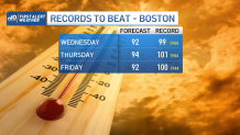
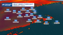
Wednesday, Thursday and Friday bring intense heat – high temperatures in the 90s – and oppressive humidity with dew points in the 70s. When this type of humidity combines with the heat, it produces heat index values of 95 to 100 degrees Wednesday and either side of 100 Thursday and Friday.
This bears the typical hot summer weather advice of hydration, lightweight and light colored clothing and limiting exertion during midday hours. It's also important to find opportunities for cooling for those who don’t have air conditioning, particularly in urban centers of southern New England.
Some afternoon showers and thunder are possible each afternoon in the heat and humidity. Additionally, wildfire smoke may drift through our New England sky over the second half of the week as the steering winds aloft shift.
A cold front enters New England Saturday and will break down the heat and humidity over the course of the day. The front is expected to spark several showers and thunderstorms as it marches across the six-state region, likely to deliver mild and less humid air Sunday into next week.
The second half of our exclusive First Alert 10-day forecast is looking pleasant and fair right now.