
We have a First Alert today for wind and rain. A powerful system is heading into New England this morning and will intensify this afternoon.
A few showers are already lifting northeast along a warm front. This will help to increase our temps to the low and mid 60s, but unfortunately we won’t have too much time to enjoy the warmth with all the rain and wind.
Heavy rain and embedded thunderstorms move into western New England late morning, central Massachusetts mid morning and Boston around noon time. From morning to afternoon in southern and eastern New England, there is a low chance for a couple spin up tornadoes.
The rain continues for a few hours, as the cold front marches eastward. By sunset the heaviest rain will be in eastern New England, clearing out west. The last bit of heavy rain heads off Cape Cod after 7 p.m.
Get Boston local news, weather forecasts, lifestyle and entertainment stories to your inbox. Sign up for NBC Boston’s newsletters.
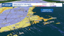
As for the wind, gusts push 50 to 60 mph for Cape Cod, Cape Ann, the islands, the south coast, south shore, north shore, New Hampshire coast and Maine coast in the afternoon. Scattered damage and outages are likely, with lots of leaf drop and slick roads.
Gusts between 40 and 50 mph will be possible in Boston to 495 as well as across the mountains. Strong 30 to 40 mph gusts are likely inland with isolated damage possible.
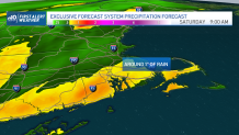
Rainfall will be around 1” through Friday afternoon, so there will be some standing water and local road flooding due to leaves clogging storm drains. Friday night we clear out and see lows in the 30s and 40s.
Another cold front heads in for Saturday night into Sunday as we will see scattered rain, with a wintry mix in the mountains. A cold pool of air aloft may also trigger pop up storms inland Saturday afternoon north and west…they may produce lightning or small hail. These are very hit or miss.
Weather Stories


Mountain snow showers continue Sunday into Monday as we anticipate 2-4” across the highest peaks and ski areas. Next week our highs will be cooler than average in the 40s through at least midweek.
