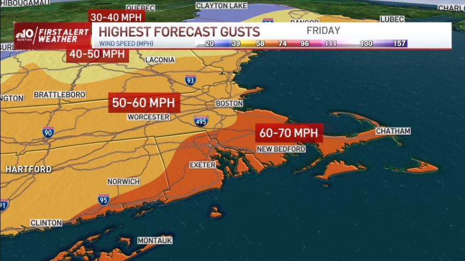
We are waking up to some power outages and damage from the wind storm overnight. Thousands of people woke up in the dark Friday morning in Massachusetts.
Our wind slowly diminishes later today as the wind direction switches and lowers a bit. Peak gusts will still be as high as 30-40 mph from the west. This ushers in colder air throughout the day.
In fact, we hit our high temperatures overnight and rapidly lower to the 30s by lunchtime around Boston. Temps continue to fall to the single digits, teens and 20s south overnight.
Sign up for our Breaking newsletter to get the most urgent news stories in your inbox.
Get Boston local news, weather forecasts, lifestyle and entertainment stories to your inbox. Sign up for NBC Boston’s newsletters.
Showers and rumbles of thunder will move quickly away from Boston after the Friday morning commute. Lingering light snow showers and a wintry mix will hang around Maine and the mountains in northern New England through early afternoon.
With all the rain, we could see some ponding on roads with the rain and snowmelt. Also watch for ice jams in northern New England and minor to moderate (VT) river flooding as we have all the snowmelt and heavy rainfall.
Colder air returns for the weekend, but it won’t be that bad. Highs still reach the upper 30s both days with a gusty wind. A clipper system will bring a quick chance for light snow on Saturday, with a few inches of snow from snow squalls in the far North Country.
Next week we have a minor system around Tuesday bringing rain with temperatures warming to around 50 again to start the work week. Another minor storm moves through for Thursday into Friday, as temps cool to seasonable highs in the upper 30s.