A severe thunderstorm warning is in place in New Hampshire and Maine as a system is causing intense weather across New England Monday.
Severe thunderstorm warnings were already issued in the Boston area Monday morning. Powerful wind gusts are expected and tornadoes are possible. Track the storm systems with our live radar below.
See updated severe weather alerts in your area here.
Where Storms Are Expected
Get Boston local news, weather forecasts, lifestyle and entertainment stories to your inbox. Sign up for NBC Boston’s newsletters.
Ongoing storms have been found across northern New England all morning, with the line slowly sinking south and east toward Boston.
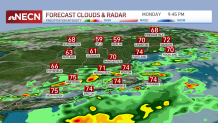
As the line of rain heads into southern New England, the environment is unstable across Connecticut, northern Rhode Island and southeastern Massachusetts. We will watch for severe storms at any point Monday afternoon. Keep an eye to the sky if you are out and about.
Damaging wind, heavy rain and a brief spin-up tornado are all threats, along with hail and lightning. Another line develops after this earlier line. The second round is part of the actual cold front that heads through Monday night.
If we see more sunshine breaking out after the first line of storms, the likeliness of severe storms increases for Monday evening across southern New England. The same threats apply for the second line through Monday evening too.
The storms move out late Monday night and then, by Tuesday morning, we’re dry and a more refreshing airmass takes over with lower humidity and cooler temps, at least in northern New England.
High Temperatures Continue
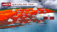
Highs Monday again reached the low 90s for a seventh day in a row in Boston with a gusty southwest wind, making for the longest heat wave in nine years.
The humidity again made it feel like near 100 degrees, with heat advisories posted around the city of Boston, out west to around Intestate 495.
Lows Monday night drop to the 50s and 60s north with low humidity. Meanwhile, the mugginess holds on a bit longer south as temps drop to the 70s and 60s.
On Tuesday afternoon, dewpoints are back in the 50s, with highs in the 80s, which is seasonable for this time of the year. We actually stay in the 80s through midweek, with a slight increase to the upper 80s for Thursday and Friday. This is also when the humidity returns.
Another cold front approaches Thursday into Friday, so plan on scattered thunderstorms and depending on the timing, strong or severe storms. Next weekend, we dry off with highs in the upper 80s, and highs around 90 will return for next week.