The nor'easter continues to rapidly strengthen south of New England Tuesday evening. Into the night, we'll see the worst of the rain and wind, with impacts lingering through Wednesday afternoon.
Rain and Timing
The rain fills in Tuesday evening, just in time for your late drive home. The rain will be wind-driven and very heavy, with the worst of it 6 p.m. to 3 a.m. Hydroplaning, ponding on the roads and almost zero visibility will be expected.
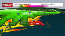
The bands of rain break up from west to east as Wednesday progresses. Northern New England misses out on any flooding rainfall, but as you go towards southern and eastern New England, we will see 1-4 inches of rain through Wednesday. Flash flooding, plus urban, small street and basement flooding are possible as well.
Get Boston local news, weather forecasts, lifestyle and entertainment stories to your inbox. Sign up for NBC Boston’s newsletters.
Wind
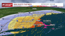
Gusts will be ramping up Tuesday evening. We see 40-50 mph winds gusting from the northeast at the coast by the evening drive. Then after dinnertime, 60-70 mph at the farthest eastern coastline. The worst of the wind is 8 p.m. to 8 a.m.
The outer Cape and eastern Nantucket may get 70-80+ mph gusts. Around Interstate 495, we are looking at 50-60 mph gusts and 30-50 mph winds farther northwest, to light gusts of 30 mph in the North Country.
The wind is cranking from the northeast Tuesday night into the Wednesday morning drive. Power outages, branches down, trees down, powerlines down and major leaf drop is expected. It will be a dangerous night and morning to drive in southern New England!
Coastal Flooding
We have, thankfully, low astronomical tides, so the flood threat is low to medium with this storm. Waves build to around 20 feet offshore for Wednesday. The Wednesday morning and afternoon tides (4 a.m. and 4 p.m.) could bring minor flooding (around 1-2 feet of inundation). Splashover will be significant as well as beach erosion as our waves stay churned up for the rest of the week.
Extended Outlook
We have a break between storms on Thursday. Another storm system develops for Saturday and will bring heavy rain and gusty wind, but it won't be nearly as strong!
The rain may linger into Sunday morning, but should get out of New England just in time for trick-or-treating on Sunday for Halloween. Stay tuned to the First Alert Weather Team for more information as these storms unfold.