A cold front will pass through the region tonight, ushering in unseasonably cold air.
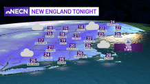
Skies will remain mostly cloudy with steady snow showers continuing across the mountains, as scattered rain and snow showers are expected through the rest of the six state region, transitioning to mainly snow showers and flurries late tonight.
Lows will drop into the low to mid 20s south, teens to low 20s north. Winds will increase, making it feel much colder with wind chill values in the single digits north and mainly in the teens south.
Get Boston local news, weather forecasts, lifestyle and entertainment stories to your inbox. Sign up for NBC Boston’s newsletters.
Sign up for our Breaking newsletter to get the most urgent news stories in your inbox.
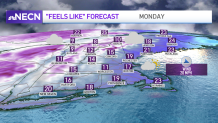
Monday will feel more like winter from Connecticut to Maine with bitter cold wind chills. It’s definitely a hat and glove day with high temperatures struggling to make it into the mid 30s south, upper 20s north with varying amounts of clouds and a chance of a few snow flurries. Snow showers will continue across the mountains with several inches, perhaps a bit more across the highest peaks. Northwest winds will continue to gust over 25mph much of the day making it feel more like the teens south, single digits to teens north.
After a frigid start Tuesday, temperatures will still be unseasonably cold with highs in the 30s north, around 40 to the low 40s south with plenty of sunshine. Winds out of the Northwest will continue to gust over 20mph making it feel colder, but are expected to diminish late in the day.
By Wednesday, winds will turn more out of the southwest as a ridge of high pressure pushes into the eastern half of the country, setting up a warming trend which will continue right through the end of the work week. This provides a chance for showers, which will arrive Wednesday night and continue into Thursday as low pressure tracks north of New England.