We’re between weather systems Tuesday. Monday night’s front has stalled to the south, while what remains of Ida crawl northeast.
Many times, we track the center of low pressure with approaching storms like this (nor’easters, tropical storms, depressions, etc.). This time, however, we’re simply following the plume of rain ahead of the storm’s track. It’s here we’ll find downpours and torrents of rain ready to travel along the stalled front to the south.
Unlike with the remnants of Henri and Fred, we don’t have to worry about the threat for tornadoes. We’re clearly on the cool side of the storm, so it’s about the water, not the spin-ups.
High temperatures will only be in the 60s as a cool breeze blows in from the northeast. Quite a change from that last couple of “remnant storms” when we had highs in the 70s and 80s along with super-humid air.
Get Boston local news, weather forecasts, lifestyle and entertainment stories to your inbox. Sign up for NBC Boston’s newsletters.
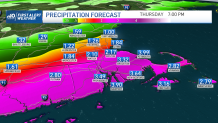
The worry really is for too much rain (stop me if you’ve heard this one before) as much of the area is doused with 1 to 4 inches of water.
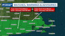
The storm itself is pretty fast-moving, but the issue is the rain will be stretched out along the front, keeping us in the fire hose for several hours. Already a Flash Flood Watch has been posted for southeastern Massachusetts, Connecticut and Rhode Island.
Weather Stories


We’ll get beyond the heavy rain later on Thursday. Probably the only good thing about getting all this wet weather is the setup in the wake of the storm. Friday and Saturday both look stellar with tons of sun and low humidity. Sunday sees the start of a warming trend that should carry into Labor Day.
Welcome, Ida?