
High pressure will provide a beautiful day across the region with lots of sunshine, warm temperatures, and low humidity.
While most of New England will remain on the dry side, a weak disturbance will kick off a few showers across northern Maine this afternoon through early tonight. With a high sun angle, make sure you grab that sunscreen if spending extended time in the sun. Highs reach the mid to upper 70s inland, slightly cooler along the immediate coastline where sea breezes will develop.
Meanwhile, well off the southeastern coastline of the United States, we have our first Atlantic Basin named Tropical Storm, Alex!

Get Boston local news, weather forecasts, lifestyle and entertainment stories to your inbox. Sign up for NBC Boston’s newsletters.
Alex, prior to being named, brought torrential flooding to south Florida over the weekend but is now no threat to the east coast of the US as it steams northeastward. It will likely be impacting Bermuda Monday afternoon with wind and rain before heading well out into the Atlantic Ocean.
With mostly clear skies tonight, we’re expecting another cool night across the region. Lows will range from the low 40s far north to the low 50s south. A few of the traditionally cooler spots in southern New England will also drop into the 40s.
Another warm and dry day is expected Monday with some morning sunshine and a few afternoon clouds. Highs temperatures will top out near 80 inland, low 70s along the coastline where the sea breeze will be more prevalent than today.
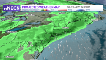
Tuesday will feature more clouds along with warm temperatures and slightly more humidity as winds turn out of the south. A shower or t-storm possible late in the day across western areas ahead of a frontal system approaching from the west, but much of the region will remain dry. Widespread showers along with some thunder arrives Tuesday night into Wednesday as the frontal system pushes through the region. Wind may also be an issue during the period, something we’ll be watching for.
Unsettled conditions continue into Thursday as a wave of low pressure rides up along the frontal boundary. Conditions look to improve Thursday afternoon and beyond, but there’s still a bit of uncertainty in the exact timing. Stay tuned!.
