
A storm system passes offshore over the next 24 hours and will head northeast.
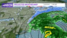
Rain, Sleet and Snow
The storm swings in precipitation on the northwestern edge and gives us rain and wintry weather. The wintry mix continues inland with some freezing rain or sleet, switching to snow and back and forth. The colder air remains across northern New England so we expect mostly light snow tonight.
A few inches of accumulation is likely through Tuesday across interior Vermont, New Hampshire and Maine. We have mostly rain along the coastline, and as far inland as I-495 tonight through tomorrow morning. Then the storm offshore pulls away Tuesday afternoon and takes the precipitation with it. Maine holds on to a little more of this snow until Tuesday afternoon.
Get Boston local news, weather forecasts, lifestyle and entertainment stories to your inbox. Sign up for NBC Boston’s newsletters.
Warmer Temperatures Move In
Our temperatures will be milder this week, as we see a quiet midweek forecast. Highs will be in the 30s to 40s through at least the first part of the weekend. This means our snow continues to melt, uncovering some new muddy spots. And keep the windshield wiper fluid topped off in the car, as road spray continues to be a problem out there. Thursday is our next chance for precipitation. So far it’s a storm heading in from Canada, and will bring in a light wintry mix as it swings a cold front through. Another minor storm system brings in rain, then snow for part of the weekend.
