Saturday was an amazing day across southern New England where we saw record high temperatures from Boston to Hartford, Connecticut!
It would be nice if we could bottle up those 50-60 degree temperatures and keep them around for a few more days, but Mother Nature has other plans for the second half of the weekend!
Hopefully you enjoyed Saturday evening because a cold front is about to make its presence known Saturday night as it ushers in much colder air in time for Super Bowl Sunday.
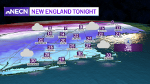
Saturday night low temperatures
Get Boston local news, weather forecasts, lifestyle and entertainment stories to your inbox. Sign up for NBC Boston’s newsletters.
Overnight we’ll see clouds on the increase and temperatures dropping into the 20s south and single digits to teens north as a cold front pushes off the New England coast.
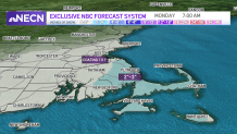
When does the snow start?
Local
In-depth news coverage of the Greater Boston Area.


Along that frontal boundary we’ll see a weak area of low pressure develop which will produce light snow showers late Saturday night across Connecticut and eventually move into eastern portions of southern New England by daybreak.
How much snow will we get?
For much of the area, we’re not expecting much in the way of accumulation, perhaps a coating to as much as an inch during the afternoon.
Temperatures remain in the upper 20s to low 30s south, 20s north.
Later in the day and evening, we’ll turn our attention to southeastern Massachusetts and the Cape where we could see an enhancement in the snow as low pressure develops off the New England coastline, but far enough out to sea not to bring any major issues.
We do have a First Alert Stamp on the 10-Day forecast being that it is a busy travel day with the Super Bowl and the threat for some snow creating some minor issues on untreated surfaces.
In terms of snowfall, about 1-3” is expected across southeastern Massachusetts and the Cape at this point.