
For many of us in New England, Saturday is the sunniest day we’ve had in a week. The system that went through Friday dropped several inches of snow at the ski areas, making today a fabulous ski day. But next up is a rapidly strengthening storm impacting much of New England for our Sunday.
Today, we have a brisk afternoon of sun and clouds mixed with wind from the southwest gusting past 30 miles an hour adding a chill to the high temperature mostly in the 30s south and 20s north.
Once again this evening any melting snow will re-freeze for spots of black ice and colder weather overnight, with low in the teens north and 20s south. Clouds will increase late Saturday night in southern New England.
Low pressure moving off the mid Atlantic states will intensify rapidly as it passes just southeast of Nantucket late in the day. Snow will develop in Connecticut about sunrise and swiftly advance to the north and east arriving in the Boston area by about 10 a.m. and then into New Hampshire and Maine by lunchtime.
In addition there’s another low pressure system north of Vermont that will cause snow to move out of New York into northern Vermont, that’s the leading edge of much colder air that’s going to fuel the north side of our departing storm Sunday night and Monday.
On Cape Cod and the Islands we may see snow mixed with sleet and rain, but likely changing to snow as the wind picks up from the northeast late in the day.
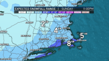
For most of us it’s several hours of snow with the potential for several inches of snow. It looks like the most will be near the south coast where we have a winter storm warning in effect Sunday for perhaps 5 to 10 inches from the coast of Connecticut to where it stays all snow on Cape Cod.
Local
In-depth news coverage of the Greater Boston Area.


Most of the metro areas for Hartford (CT), Boston (MA), Manchester (NH) and Burlington (VT) probably come in the order of 2 to 5 inches of snow.
The big exception could be downeast Maine as the storm is really intense at that point with more than a foot possible in Hancock and Washington County.
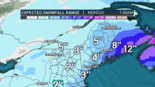
For most of us the snow is done as the Super Bowl is being played. The exception is from the Maine mid coast and points east where it may snow most of the night.
It’s a very busy weather map after that, too.
There’s a frigid air mass in the northern plains where temperatures are struggling to 10 below zero for highs and the wind chill factor is 30 below zero in North Dakota and Minnesota.
Several low pressure systems rounding below that cold are going to come through New England this week -- probably one every other day.
In between the storms it should be cold on days like Monday with a return to sunshine mostly in the 20s. Then several more inches of snow Tuesday. Then maybe dry Wednesday and to begin Thursday, before another system late week.
A major change to our forecast is that the cold is not going to rush in late week, that’s going to allow the next system Friday to be much warmer than we anticipated with a possibility of snow or rain Thursday night into Friday.
Then maybe drier -- but rather cold -- next weekend as seen in our First Alert 10-Day Forecast.
