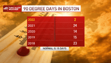
With the big storms behind us, we’re turning our attention to the heat in the coming days. This will not only be the first heat wave (three straight days of 90+ degree heat) for many this season, but also the start of long hot spell that stretches into the weekend.
Humidity drops today, but it’s only briefly. Dew points start to creep back as early as tomorrow, with the stickiest air waiting for Thursday. Then that combination of heat and humidity makes it feel like 100 degrees in spots.
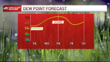
Highs on Thursday will peak in the mid and upper 90s, marking the hottest day of the year and of this hot spell. Granted, it’s not like there will be a marked drop off in temperatures after Thursday, but we will have a change in the air come Friday. Temps near 90 likely will continue into the weekend.
Get Boston local news, weather forecasts, lifestyle and entertainment stories to your inbox. Sign up for NBC Boston’s newsletters.
It’s been a while since we’ve seen this kind of heat, so here’s a refresher:
- Guzzle lots of water
- Seek shade and A/C whenever possible
- Exercise indoors or in the early morning outside
- Take frequent breaks if working outside
- Look for signs of heat exhaustion & stroke (exhaustion, rapid heart rate, overheating)
Get updates on what's happening in Boston to your inbox. Sign up for our News Headlines newsletter.
After last night’s drink of water, many were left wanting. We’ll see another chance for storms in the steamy heat of Thursday afternoon, and again on Sunday afternoon. Sadly it’s the same old story: some hits, many misses.
Be safe and keep your cool.