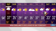
It’s a mild finish to our week with an interesting forecast for the weekend!
A frontal system pushed in Friday morning, bringing our temperatures down just a few degrees. But as brief high pressure system is nudging in, our highs remain in the 50s with mostly sunny skies and a fantastic afternoon to wrap up the work week.
The temperatures will drop into the 20s and 30s Friday night, which will bring in the chance for some snow to fall in several areas of New England as a low pressure system tracks near our south shore.
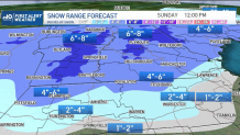
Snow is expected exclusively for much of the northern half of New England, including ski and snowmobile communities. Southern New England, on the other hand, will find a mix of snow, sleet and rain, depending on location.
Get Boston local news, weather forecasts, lifestyle and entertainment stories to your inbox. Sign up for NBC Boston’s newsletters.
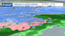
The storm begins Saturday morning, when rain showers move into Connecticut and mix with snowflakes over the course of the morning. Snow will begin to fall in the Berkshires to southern Vermont.
While southern New England starts as a light mix of rain and snow, many communities will transition to all snow for a time as temperatures drop. Roads will start wet, but will turn slick by middle to late afternoon and entirely snow covered where not treated.
Southeastern Massachusetts, southern Rhode Island and perhaps areas nearest to the eastern coast will be the exception, where milder ocean air will help to keep temperatures above freezing.
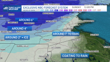
In central and western Massachusetts, total snowfall amounts should reach 2-4” before sleet takes over. This still poses a travel headache for these inland spots, though.
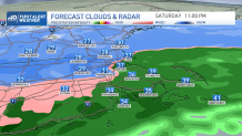
The Boston Metro will likely go from snow to a wintry mix and then rain for the rest of Saturday night. Temperatures are expected to rise a bit more as the wind shifts in from the east, holding amounts down compared to the interior.
Our mountains, on the other hand, should end up with six to eight inches of snow -- great news for ski resorts and powder fans. By noontime on Sunday, we’ll be working on drying up.
Most of New England will be enjoying the winter vibes with highs in the 30s. A mostly cold week ahead is expected.
Weather Stories


Our First Alert Team is not only watching an offshore storm at midweek, but also keeping a close eye on a disturbance that may make its way in toward week's end, bringing the chance for some flurries or snow right on time for Christmas.
This may still change since we’re still pretty far away from that, but stay tuned for all the updates.