Ida is no longer a hurricane…or a tropical storm…or a tropical depression. But does still represent a slug of rain and a low pressure center – a storm center – churning northeast, dumping flooding rain along its path and heading for New England.
In the interim, humidity has decreased Tuesday behind a cold front that swept off our New England coast in the predawn hours and brought a wind shift to open the door to more comfortable air from Canada and the Great Lakes.
While high temperatures return to the 80s for a second day in a row, it feels decidedly different than Monday. Dew point temperatures – the measure of the amount of moisture in the air – dropped from the 70s to the 50s.
The drier, more comfortable air will hold rain at bay for a while. But the wealth of tropical air streaming north ahead of Ida’s remnant center will first bring high-altitude clouds Tuesday, then thickening clouds Tuesday night into Wednesday. Showers will develop from southwest to northeast across southern New England Wednesday morning to afternoon, then into an all-out rain Wednesday night through Thursday.
Get Boston local news, weather forecasts, lifestyle and entertainment stories to your inbox. Sign up for NBC Boston’s newsletters.
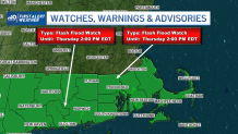
With the heaviest tropical downpours expected between midnight Wednesday night and midday Thursday, total rain amounts near and south of the Massachusetts Turnpike likely will reach two to four inches. There could be localized flooding – urban, street, stream and some small river flooding – and Flash Flood Watches have been hoisted in this area.
Although amounts may be a bit less north of the Pike, much of central New England should still see a one to two inch rainfall with much less in northern New England, and almost nothing in the far North Country.
With the counter-clockwise swirl of air associated with the storm center passing to our south, most of New England will find a gusty north-northeast wind Thursday. Ida’s remnant center will find some renewed strength over the ocean waters to our south, meaning gusts of 35 to 50 mph are possible Thursday, especially near the coast.
If the storm center moves a bit farther north, the wind may turn to blow from the south over Cape Cod and increase the chance for severe thunderstorms, too, but that’s not extremely likely at this point.
By Thursday late day and evening, rain will taper to showers and a burst of drier air is expected by Friday. While some scattered mountain showers may pop up Friday, most of New England will start drying out, en route to a great weekend of fair, pleasant weather.
Labor Day Monday is likely to bring a push of slightly warmer air – around 80° for many – ahead of an approaching disturbance. That will deliver scattered afternoon and evening thunder with an attendant cold front, and a similar pattern may repeat again for the middle of next week in our exclusive, First Alert 10-day forecast.