We’re enjoying another wonderful afternoon today, our highs are reaching the upper 40s and even climbing to the low 50s in the south.
Our skies have brought us plenty of sunshine, marching clouds will make their way into the area this afternoon but our chances for isolated snow sticks near the Canadian border.
We’re getting ready for our next storm system tomorrow. This will bring plenty of rain early in the morning southeast, heavier downpours through the late morning and midday.
Sign up for our Breaking newsletter to get the most urgent news stories in your inbox.
Get Boston local news, weather forecasts, lifestyle and entertainment stories to your inbox. Sign up for NBC Boston’s newsletters.
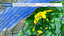
But the snow begins in northern Vermont early as well, it will remain in the north until after midday. As our temperatures drop through the evening, we’ll see the snow line pushing south closer to Worcester and near Boston by around 4 p.m.
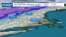
Rainfall amounts could add up to more than 1” south, but our snow totals remain limited in the south, giving us only from a dusting to 2 inches. The farther north and west you go, the higher snowfall amounts we’ll see.
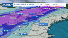
Our snowfall in the Berkshires could add up from 4-8”, while the higher spots up in Vermont could go up from 8-12 inches total. Northern Maine will also see from 6-8” of snowfall with a light dusting to 2” as we get closer to the coastal communities.
While Sunday promises bright sunshine, our highs remain cold, we’ll remain in the 30s, active winds will make it feel like the teens to the low 20s. Next week is bringing us more spring-like temperatures with highs in the upper 50s for St. Patrick’s day. Rain chances will also pop up by the end of our next work week.