
Mild temps are still around this morning, with lows in the 40s and 50s. A few clouds are rolling by and the wind is more from the west, which is an indication that a front has moved through.
Temps stay in the low 50s today with a partly cloudy to mostly clear sky. We slowly cool off into Saturday morning with lows dropping into the 30s ahead of a wintry mix. Saturday morning is cloudy and cold with temps in the 20s north and 30s south.
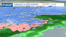
Our storm system slowly approaches from the southwest and this brings in light snow across western Massachusetts and Connecticut late morning. By noon time, the snow approaches Worcester to Boston, by mid afternoon the precipitation is all over the northeast.
Get Boston local news, weather forecasts, lifestyle and entertainment stories to your inbox. Sign up for NBC Boston’s newsletters.
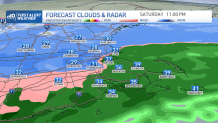
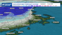
In Boston, we go from snow and a little accumulation on grassy areas to a mix and rain for the rest of the system Saturday night into Sunday morning. In fact, the coast to southeastern Massachusetts will see just a cold rain for most of this storm. A low impact to travel and holiday shopping.
Outside 495, it gets more complicated with a moderate impact. We see snow to a mix, and possibly a back and forth changeover Saturday night around 495 and the Mass Pike. This is the area of uncertainty, where we aren’t sure yet how much warm air aloft noses its way in from the south.
The track of the storm also could increase snow totals slightly, or decrease them. Plus, a coastal front seems to set up around the New Hampshire seacoast down to the South Shore. That will also cut down our snow chances depending on how far inland that tracks.
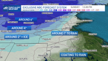
With all these things into account, we still anticipate a great snow forecast for the mountains- several inches! Around Worcester, about 2-4” of snow and some mixing.
Southern New Hampshire to the Worcester Hills and the Berkshires will get around 6” of snow. Boston will see around 1” then it will get washed away Saturday evening by the rain. Stay tuned for updates on the track and totals!
Sunday marks the beginning of a colder weather pattern as temps fall to the 30s. We have pretty quiet weather next week as temps stay in the 30s or 40s through Christmas weekend.
Weather Stories


Odds will be that we don’t have a white Christmas in Boston, Providence or Hartford (at least 1” of snow on the ground Christmas morning).
However, if you head up north to Vermont, New Hampshire, and Maine inland you will have a white Christmas! And there should be a few festive snowflakes around as a weak system moves through Christmas Eve.
