The winds grew tiring this weekend, and now they’re bordering on hateful. We have one more day of gusts near 40 at the coast (occasionally to 30 elsewhere) as the storm center has stalled off the Carolinas.
I know what you’re thinking. That is a mighty long distance from us. How in the world are we still getting winds from that storm? Well, it’s a wide, wide wind field, and we’re wrapped up in it.
As is often the case with ocean-born storms, the winds are whipping over the (nearly frictionless) water, so the coast/Capes/Islands take it on the chin while the inland communities see lighter fare. Sunshine isn’t helping matters, either. It helps mix the air and keep the gusts alive. At night, the winds back off like clockwork.
Get Boston local news, weather forecasts, lifestyle and entertainment stories to your inbox. Sign up for NBC Boston’s newsletters.
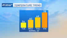
Wednesday we’ll turn a corner and see the winds back off in the afternoon. Highs will leap to near 70 away from the coast (specifically in central Mass.) as the Sun continues to dominate. Thursday we start moving in the warm direction as highs near 70 a bit closer to the I-128 belt. Still a semblance of a sea breeze the coast.
As high pressure builds through the upper atmosphere later this week and this weekend, the highs soar into the 80s. Humidity will be on the climb as winds turn in from the south and southwest. Ironically, our current storm will have made “landfall” in the southeast and turn the corner to make a run at us here in the northeast.
Get updates on what's happening in Boston to your inbox. Sign up for our News Headlines newsletter.
This isn’t a washout scenario for the weekend, however. The storm will be much weaker and will have transformed into a batch of thunderstorms. They mainly threaten Sunday and Monday, but we’ll be on the lookout for any hit-and-miss storms as early as Saturday afternoon.