Although the pattern isn’t as stormy, it’s still pretty active. That means weak weather systems will ripple through over the next few days. While none of them are capable of bringing in the arctic cold, they will be able to boost us close to 50 (or above at some point).
Today is a respite from the storms. Highs won’t move far from the 40 degree mark and sun should dominate throughout the morning. A few afternoon high clouds will stream in to cap off a fine winter day.
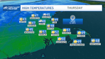
Thursday is mired in a plenty of clouds, but we should be able to muster a few upper 40s (if not 50) as the winds turn southwest. A couple of showers accompany a swift-moving front by midday, but this is hardly a washout. This weather system is moving so fast, it won’t have time to drag down the colder air for Friday, so our high temps again will level off in the 40s.
Get Boston local news, weather forecasts, lifestyle and entertainment stories to your inbox. Sign up for NBC Boston’s newsletters.
This positions us for a very mild (for February at least) Saturday forecast where high temperatures are catapulted way above 50 in most spots. Here too, a few showers may swing through around midday with the passage of another front.
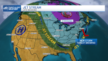
We’re closely watching the Sunday-Monday time frame for a storm developing offshore. Cold air will drop in Sunday and although a lot of our guidance was ambivalent about a storm at first, there seems to be something lurking off Nantucket.
Could this be an accumulating snow? Certainly. IF the pieces all fall into line – including keeping the track near the coast. Time will tease out the details as we glide toward the weekend.