Our mostly dry and warm pattern continues to roll on.
Though some cities and towns were fortunate enough to receive a decent rainfall from yesterday’s storms, many were left out with barely enough raindrops to wet the ground. Our dry pattern continues through the weekend, which is great if you have outdoor plans, but not so great since much of the region is now seeing a moderate drought, with severe drought levels across northeast Massachusetts into southern New Hampshire.
Today will feature mostly sunny and warm conditions across the region, with the exception of southeastern areas as some high thin clouds associated with a frontal boundary south of the region will continue to stream overhead. Humidity levels will be low with highs reaching the low to mid 80s across the interior, upper 70s along the coast due to sea breezes, and upper 70s in far northern New England.
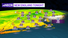
Overnight we’ll remain mostly clear and comfortable with lows dropping into the 60s south, 50s central and northern New England. Along the coastline, we may see some minor splash over during the overnight high tide cycle due to an astronomically high tide, but there shouldn’t be any major issues there.
Get Boston local news, weather forecasts, lifestyle and entertainment stories to your inbox. Sign up for NBC Boston’s newsletters.
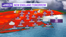
Another beautiful day is shaping up Saturday with warm temperatures and low humidity. Most of the region will remain dry, but can’t rule out a very isolated shower/sprinkle bubbling up across the interior during the afternoon.
Enjoy Saturday, because the humidity is set to return on Sunday with warmer temperatures. A few afternoon showers and storms may pop during the afternoon, but not expecting any drought busting rains, but hey, we’ll take what we can get.