
There have only been 14 Category 4 or 5 hurricanes to make landfall in Florida on record, and we’re going to be adding another one to the list this afternoon. Hurricane Ian remains a powerful Category 4 storm as it slowly approaches the west coast of Florida, and landfall is anticipated within the next couple of hours near Boca Grande. Widespread damage is ongoing and outages are anticipated to last for weeks, if not longer in parts of the sunshine state. Billions of dollars of damage will result from the surge, wind and flooding.
Per the 1 p.m. update from the National Hurricane Center (NHC): “A River, Estuary, and Coastal Network station at Redfish Pass, Florida, recently reported sustained winds of 75 mph and a wind gust of 100 mph, while a Weatherflow station near Sanibel Island, Florida, recently reported sustained winds of 77 mph and a wind gust of 107 mph. The Earth Networks Station at the Naples Grande Beach Resort recently reported a wind gust of 112 mph.”
Dangerous winds from Hurricane Ian
As the eyewall of Ian has been moving over the coast of western FL, Extreme Wind Warnings have been issued. Those that did not evacuate are urged to shelter immediately. The strongest core of wind will continue from Sarasota to Fort Myers, within 45 miles of the storm center, through this evening. Tropical storm force gusts extending 175 miles from the eye, and will encompass much of the state by tonight and tomorrow.
Get Boston local news, weather forecasts, lifestyle and entertainment stories to your inbox. Sign up for NBC Boston’s newsletters.
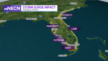
Storm surge impacts
Images from the storm surge have been heartbreaking as the water continues to rise, particularly from Pine Island to Sanibel and Fort Myers. At the same time, you may have seen some video or pictures of other areas “draining out” – on the north and northwest side of the storm, literally sucking the water out before surge moves in. The east coast of FL isn’t totally removed from the surge threat. As the storm emerges off the east coast, the surge threat will shift from Daytona to Jacksonville, FL then along the coast of southeast Georgia & South Carolina.
The storm will bring rain to multiple states and tornadoes to Florida
Weather Stories


Heavy rain and torrential downpours will continue to move through Florida, reaching portions of the southeast US on Friday and for the weekend. Widespread flooding is expected, with major and record river flooding anticipated across central FL. The highest rainfall totals will be on the order of 12-18” with higher amounts from central and northeast Florida. Eastern Georgia and much of South Carolina will see 4-8” with locally higher amounts. A tornado watch remains in effect until 5 p.m. for central and southern Florida where a few additional spin-up tornadoes are possible.
How Hurricane Ian could impact New England
The northern shield of clouds from hurricane Ian will arrive to southern New England with a veil of clouds dimming the sunshine by Friday and those clouds will stay in New England all the way until next Tuesday! The bulk of the rain associated with a decaying Hurricane Ian this weekend will stay south of New England. However, some showers will try to spread north, particularly by the time we get to Saturday evening, especially the farther south one is. So the coast of Connecticut to Rhode Island and Cape Cod have the highest chance of some wet weather Saturday – and this is something we’ll be fine-tuning in the next couple of days.
