
Nearly five days after Hurricane Ian made landfall, New England gets the storm’s final act. While Ian’s curtain call is nowhere near the strength it previously was, the remnants will produce gusty and breezy conditions and cooler temperatures.
Modest upper level energy has emerged along the mid-Atlantic coast and it’s not until strong flow aloft comes by Wednesday evening to lift it out, do we see winds relax. Because the area of low pressure is centered near the Delmarva Peninsula, most of the heavy will be focused from New England’s south coast and throughout the greater D.C. area. Estimated rainfall since Saturday has been near 2.5” on Nantucket, close to 3” for Philadelphia, and around 5.19” for Atlantic City, New Jersey. Most locations around Boston have drawn between a trace and a tenth of an inch, but the odds go up through Wednesday as the remnants pull energy in offshore.
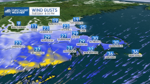
With a tightening pressure gradient, winds remain gusty. Gale warnings are posted for the entire Northeast coast as northeast winds gust near 40 mph. This will create choppy waters off the New England coast, with seas between 9 and 12 feet.
Get Boston local news, weather forecasts, lifestyle and entertainment stories to your inbox. Sign up for NBC Boston’s newsletters.
As the system diminishes Thursday, we then turn our attention to a cold front arriving later this week. As of now, it doesn’t appear to be a substantial rainmaker. The bigger impacts will be another drop in our temperatures, with many into the low 40s Saturday evening and Sunday morning. The continuum of cooler nights will expedite fall foliage, and bring several regions that much closer to peak foliage.
