Severe thunderstorm warnings were in effect Thursday afternoon and evening in parts of Massachusetts, Vermont, New Hampshire and Maine, but they have since expired. Flash flood warnings were also issued in parts of Maine, but those have ended, as well.
Click here to see the latest severe weather alerts.
Humidity makes a comeback for our Thursday and sticks around through Friday. Thursday morning found a warm front migrating slowly northeast into New England, taking early sunshine and mixing it with increasing clouds and isolated showers and downpours.
As the day wears on, isolated to scattered showers with embedded downpours continue to crop up, slowly transitioning from south to north across southern, central and northern New England, remaining scattered enough that nearly all communities find many more dry hours than wet Thursday.
Get Boston local news, weather forecasts, lifestyle and entertainment stories to your inbox. Sign up for NBC Boston’s newsletters.
By Thursday afternoon, the showers and downpours will gain some organization in northern New England, particularly New Hampshire and Vermont. That's where embedded thunderstorms will develop, fueled by the incoming and increasing humidity that makes for a sticky afternoon in much of New England.
By Thursday late day and evening, these increasing thunderstorms will have enough fuel from warmth and humidity to deliver pockets of locally damaging wind gusts in stronger storms, starting in Vermont and New Hampshire but moving southeast into the Boston area and the eastern New England coast around sundown. That will result in a loud start to the night for towns that are impacted by the lightning and downpours.
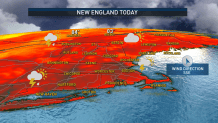
The further south one is, the lower the chance for evening and night thunder, with the South Coast probably only seeing a passing shower in the first part of the night before pockets of fog and clouds fill in owing to the abundant humidity. Friday continues to feature humidity, but there’s really no strong disturbance ahead of an approaching cold front, so most of the morning through middle afternoon should be dry with breaks of humid sun between clouds.
When the incoming cold front arrives late Friday into Friday evening, scattered showers and thunder are probable, but winds aloft aren’t favorable for much strength with this round, and behind the cold front a new wind delivers fresh and pleasant, low humidity air from Canada for both weekend days.
Saturday actually may find so much cool air aloft – air near the ground will still be in the 80s – that some afternoon puffy clouds will develop enough for a few showers or a sprinkle in northern New England. Meanwhile Sunday just looks dry and bright across the board with highs well into the 80s again, but humidity remaining comfortably in check.
Heat is expected to build next week, even if humidity is a bit slower to return, with most days at or over 90 degree high temperatures, meaning some communities may record a multi-day heat wave again!
The highest storm chances next week, though still scattered, appear to center on late Tuesday and again toward Friday, depending on the speed of weak disturbances at the jet stream level and just how much humidity moves into New England.