In case you missed it, we have reached the statistical peak of the Atlantic hurricane season, which was Saturday, September 10. And many of us probably missed it, since it has been extremely quiet, so far.
This is actually the least active start in 30 years, with only twice in history getting no named storms in August. September is typically the time our season really turns it into overdrive with about 60% of named storms falling between now through the end of the season on November 30.
September brings us some favorable conditions for storm organization: warmest sea surface temperatures, and low wind shear, plus minimal Saharan dust off the coast of Africa. And the central and southern Atlantic sees the highest chance for storm development during this month. The Gulf of Mexico also has a climatologically high chance for storm development.

Get Boston local news, weather forecasts, lifestyle and entertainment stories to your inbox. Sign up for NBC Boston’s newsletters.
So far we have had five named storms. The last two did strengthen to hurricane status (Danielle & Earl) and thankfully remained well offshore.
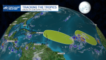
Currently, there are two disturbances in the eastern and southern Atlantic. Both have a 0% chance of developing in the next two days, with a 20% or low chance, of development in the next five days according to the National Hurricane Center. These thunderstorm clusters are expected to move through more wind shear in the upper levels of the atmosphere and that will prevent storm organization.


