
Today marks the end of July and one that will fall into the record books for being the third-warmest July in Boston's recorded history, with the monthly average temperature running about 3.5 degrees above normal.
Not only will July 2022 make the top five for warmest temps, we'll also end up in the top five – likely fourth – for driest ever, with Boston only receiving about 0.62 inches of rain for the entire month (the average is 3.27 inches).
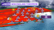
High pressure will provide the region with another very warm and mostly sunny day. A few high, thin clouds will dim out the sun later this afternoon south as a system approaches the area from the southwest which will eventually usher in more humid conditions to start the new work week as winds turn more out of the southwest later today. Highs today reach the mid to upper 80s inland, mid 80s coast.
Get Boston local news, weather forecasts, lifestyle and entertainment stories to your inbox. Sign up for NBC Boston’s newsletters.
Overnight clouds will be on the increase along with humidity as we enter a southerly airflow. A few showers will break out along the South Coast late tonight and linger across the Cape and Islands through the mid-morning Monday, but should exit by the mid to late morning hours. Lows tonight in the upper 60s, highs Monday in the mid to upper 80s.
Hot and humid Tuesday with clouds and sun. A weak frontal system will trigger off a few showers and storms, mostly across central and northern areas. After a brief break from the heat and humidity Wednesday, we turn extremely hot Thursday with temperatures pushing 100 which has prompted us to put a First Alert stamp on Thursday.
