This could very well be the pick of the work week. Sunshine still has the upper hand, temperatures recover to the low 60s in spots, and the day stays dry.
Can’t say that about the next two, however. Showers move in early tomorrow, and with a steady east wind, there’s not much to love about the forecast. Highs will struggle to even break the mid-40s with the raw breeze off the water.
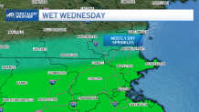
There is still the possibility that northernmost Massachusetts and southernmost New Hampshire miss out on the steady rain, with just some afternoon sprinkles passing through from time to time. Either way, no one is getting away with 50 degrees under the clouds and showers.
Sign up for our Breaking newsletter to get the most urgent news stories in your inbox.
Get Boston local news, weather forecasts, lifestyle and entertainment stories to your inbox. Sign up for NBC Boston’s newsletters.
Thursday will see another round of rain moving in during the afternoon. Again we can expect very little in the temp department. Another day spent in the 40s.
We’ll turn things around by Friday as this system departs and the sun returns to warm us into the 60s. We’ll still be wrapped up in the upper level storm, so we could sneak in another shower both Friday and Saturday afternoon.
Long range things may be really cooking. A pattern change could bring more summery temps our way next week. The details are still emerging, but there is some confidence in the long lead time of 7-10 days. Stand by for details in the coming days.