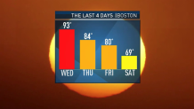
After our last searing, long-lasting heatwave, you'd think the cool down would be a bit softer. But no, in grand New England fashion we went from frying pan to gentle simmer.
Summer is on hiatus for the next two days. A commanding area of high pressure over Northern Maine will keep the winds brisk and the temperatures cool, especially along the coast.
Some gusts could top 30 mph early Monday from Cape Cod to the Islands with the passage of a juicy storm system. Sadly, this high is a big bully and will do its best at suppressing/evaporating much of the rain as it attempts to cozy up to Southern New England Sunday night and Monday morning.
There was a lot of beneficial rain at stake with this storm, but there's not much sense in crying over the could-have-beens. We're already looking ahead to Tuesday and the prospects of afternoon thunder as summer warmth returns and highs top 80 across the region.
Here too, the rainy prospects disappoint rather than delight. It's looks like lawns and gardens stay dormant and dead for yet another week as the cooler air swings back into the picture by the middle of the week.
If you're thinking of dipping your toes in the sand, the surf is rough at the beaches. Departing Tropical Storm Kyle and the gusty wind from our big high pressure system have spawned some big waves. Keep your eyes peeled for rip currents, and enjoy the rest of your weekend.