It’s snowing!
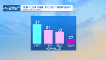
But it’s not much of a bother this morning. Wet roads, light snow…and not much to show for it. Accumulations will be light, if at all. This is all in response to the slow-moving cold front sliding through the Commonwealth through the morning. As its name implies, the air will get colder…much colder as the day wears on. With that said, the afternoon and evening drive could feature some slick spots as we crumble from near 40 this morning to the 20s late day.

Winds won’t be strong, but steady enough to bring in a bit of a wind chill overnight and into tomorrow morning. We’re expecting it to feel like temps below zero first thing in the morning. We’ll start with air temps in the low and mid-teens and only aspire to reach near 20 in the afternoon. Saturday isn’t much warmer (after a start in the single digits), but low 20s could be in play as we watch what “coulda, woulda, shoulda” been a storm sail far out to sea southeast of Nantucket.
Get Boston local news, weather forecasts, lifestyle and entertainment stories to your inbox. Sign up for NBC Boston’s newsletters.
This had all the makings of a big storm for New England…if it tracked closer. Instead, we have some possible ocean effect snow showers on the South Shore and Cape that COULD sweep through. Accumulation would be minimal, but it’s something to watch.
Other than that, the pattern is relatively quiet – and cold. Temps recover on Sunday into the 30s, only to fall back into the 20s on Monday.

