
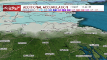
We had a large swath of 6"-8" of snow across central New England for today. The heaviest snow for southern New England is over. Northern New England will see more snow until late evening and another 2"-4".
Icy conditions possible as refreeze hits
As the storm system wraps up, it brings a few more snow showers across Boston and to Cape Cod as temperatures in southern New England crash. We reach the 20s in Boston by dinnertime, so watch for everything to refreeze. Icing is the big concern even along the south coast and Cape Cod after those areas had mostly rain. Tonight’s lows drop to below zero far north, single digits to teens south. Cape Cod and the islands will see some ocean-effect snow showers through the morning that could bring another coating-2" of snow there.
Get Boston local news, weather forecasts, lifestyle and entertainment stories to your inbox. Sign up for NBC Boston’s newsletters.
Cold and quiet Saturday
Highs tomorrow will be in the 20s north and around freezing south. Blue bird skiing across any New England mountains too! Fresh powder and minimal wind along with the sunshine make it ideal to take a trip to your favorite ski area.
Weather Stories


Snow squalls possible Sunday
Sunday brings more wind and potentially ski lift delays. Along with a clipper system that triggers some snow showers or snow squalls. Highs Sunday reach near 40 in southern New England before the wind picks up and a cold front heads through. There may be a snow shower around Boston Sunday afternoon too.
Sunshine to start the work week
Colder air returns for Monday as highs stay in the mid-20s. We keep sunshine around to start the next work week. Highs increase slowly to the mid-30s Tuesday, then to the 40s for midweek. No major systems are on the schedule for next week. There is a minor low-pressure system for Wednesday into Thursday and will bring a wintry mix chance. There is another storm system that will bring in a chance for rain then snow sometime next Saturday into Sunday.
