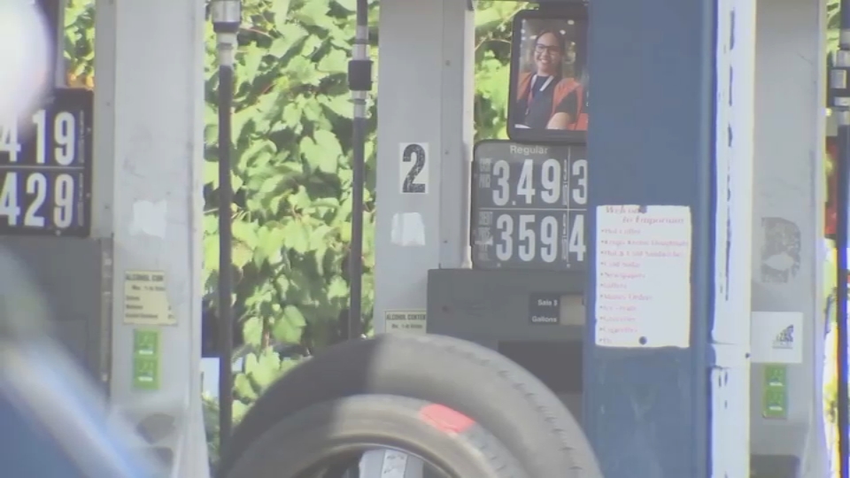
Another soaker to wade through today. Unlike yesterday, which featured a break in some spots (and sun over far northern New England), this will be a constant stream of rain – with occasional pauses. It jeopardizes the Red Sox game this afternoon, but with the grand finale of heavy rain tonight, it may lead to isolated flooding.
Already some spots of topped off at near 3 inches of water. With another leg of rain today and the heavier rain in storms tonight, we will be water logged. The storm pushing in from the south today is tapping into some serious water vapor channels. Thunderstorms will squeeze every ounce of juice out of the atmosphere and the end result may be another 2-3 inches in some isolated spots.
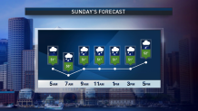
There’s some glimmer of hope to the holiday weekend. Drier air will fly in on the heels of all the departing rain Monday afternoon. After a murky start to the day, we should see some sun break through the clouds. Air is still somewhat unstable, so we’re not overselling the sunshine in the afternoon. It should still get bright enough to yank us back into the 60s.
Get Boston local news, weather forecasts, lifestyle and entertainment stories to your inbox. Sign up for NBC Boston’s newsletters.
We won’t stop there of course. Warmer temps will return by Tuesday (of course) and the long range has us back in the frying pan late in the week and into next weekend.
I know the rain is already getting old, but try and enjoy the rest of the holiday weekend.
Local
In-depth news coverage of the Greater Boston Area.