
Not a peep out of any storms or numbing cold this week.
That about sums it up.
Well, there are clouds. A sampling will swing through today, occasionally blotting out the sun. In fact, there are numerous small, weak weather disturbances zipping by in the jet stream through the middle of the week. None of these has the power to alter our temperatures much, however.
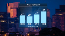
We hover near 40 degrees each afternoon around Boston, and settle for 30s in northern New England. With an average high of 36 for the city, you wouldn’t think that we’re far from normal in the coming days. But it’s the overnight low that catapults us into the realm of much above normal. We should be around 22 degrees, but instead will be 28-29 degrees on most nights.
The storm over Texas is heading eastbound, but it exits the Eastern Seaboard tomorrow with a whimper. Oddly, the storm will weaken from a bold snow-producer to a disorganized band of showers in the Carolinas by Tuesday evening.
Where’s the real cold? And will it make an appearance in New England? Some of it is in Siberia. And no, it won’t anytime soon. If anything, the cold in Siberia will expand and deepen in the coming week to ten days, while we get a reinforcing shot of colder air – essentially refreshing our cold – by the middle of the weekend.
Weather Stories


The big message of the week is that another warm up is in store. As we build on the 40s through midweek, a milder storm will nudge us to 50 or above by the start of the weekend. Showers are headed in as well, to add a little excitement to an otherwise flat-lined forecast.
Have a great week!
