
After a messy pattern bridged November to December with every type of wintry weather, a quieter weather pattern has arrived just in time for the holiday stretch.
While this means no fresh snow will fall on New England by Christmas – and many communities in central and southern New England will lose snow in the 72 hours leading up to the holiday – it certainly means great conditions for local travel.
Air travel meets with a different story depending on your destination. The southeast U.S. is seeing a storm of wind and rain causing hundreds of delays in Atlanta, North and South Carolina airports and most Florida airports. Meanwhile, Southern California sees a separate storm that will cause many delays there, including Los Angeles.
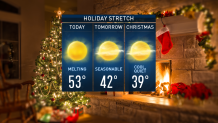
Perhaps the most noteworthy aspect of our weather at home in the next couple of days will be Monday’s high temperatures over 50 degrees in most of central and southern New England.
Those mild temps will finally melt some of the hardpack snow and ice on driveways and sidewalks. They will also make puddles and wet ground that will increase both glare and road spray, making sunglasses and windshield washer fluid two helpful accessories during this holiday week.
Weather Stories


Monday’s warmth peaks with an increasing southwest wind during the afternoon and evening, ahead of a cold front that shifts the wind to blow from the northwest Monday night, delivering a shot of notably cooler – but continued dry – air.
As a result of the new air, high temperatures Christmas Eve Day Tuesday will hang either side of 40 degrees – some 10 degrees colder than Monday. That new, cool air continues through Christmas, but so does the dry combination of sun and clouds with just patchy overnight black ice in areas of melting and refreezing.
The next disturbance capable of delivering a few rain and snow showers will cross the New England sky Friday without much fanfare, while a larger storm is in the offing for next Sunday into early week. It will likely start as mostly rain but perhaps end as a mix with some snow or ice.
It is likely to exit before New Year’s Eve festivities in our exclusive First Alert 10-day forecast.
