
Beautiful summer weather is on tap for much of New England to kick off our week, with highs topping out well into the 80s to around 90. The thunderstorm risk Monday is very low, although we can’t rule out a stray shower or storm in far northern New England.
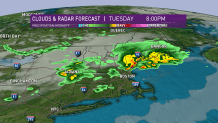
Tuesday will be just as hot, except in northern New England, where an approaching cold front will bring clouds and showers, keeping our temperatures in the 70s to around 80. Thunderstorm action will be scattered in nature, with a few strong to severe cells possible from mid-afternoon into the early evening from west to east. Keep an eye to the sky and be ready to duck inside should you need to.
Behind this front, less humid and noticeable cooler air will move in for Wednesday.
Get Boston local news, weather forecasts, lifestyle and entertainment stories to your inbox. Sign up for NBC Boston’s newsletters.
Our active pattern continues this week with the next disturbance arriving later Thursday. Clouds will increase, with rain likely arriving during the afternoon (although timing is still a bit certain) and lingering into early Friday.
The good news is that the overall trend is to dry us out Friday and start our weekend off with beautiful weather. Highs will be in the 70s to around 80 for an extended stretch with no big-time heat or oppressive humidity in our exclusive 10 day forecast.
