
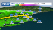
It’s a bit of a dismal start to the work week, as waves of low pressure and a stationary boundary to our south continue to focus periods of wet weather over parts of New England.
Pockets of rain in central and southern New England will continue off and on through the remainder of the afternoon and evening. No widespread flooding is likely, although some minor urban and street flooding is possible and you’ll certainly want to take it a bit slow on the roads.
On Monday night, some heavier rain will fill back in for a time, and an additional half inch to 1 inch of rain is likely in many areas, with a few higher totals possible.
Get Boston local news, weather forecasts, lifestyle and entertainment stories to your inbox. Sign up for NBC Boston’s newsletters.
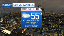
After a rainy start Tuesday morning, expect conditions to gradually improve throughout the day as the rain tapers to showers. Clearing will arrive to northern and central New England late in the day, and a few breaks of sun may try to emerge in southern New England just prior to sunset.
That means the Wild Card game for the Sox versus the Yankees at Fenway Tuesday night will be good to go, with a wind in from left field and cool temperatures.
By midweek, a beautiful stretch of weather sets up again, with plenty of sunshine, dry conditions and above normal temperatures. At this point, our Columbus Day weekend is looking cooler (in the 60s) and mainly dry.
Weather Stories


I say "mainly" because a backdoor front will push through and could bring a few light showers/sprinkles late Saturday and in western New Englandon Sunday -- but no washouts!.
A storm will pass close to the South Coast on Columbus Day itself, so we’ll have to watch the position of that closely to see whether we can hold onto a dry day. Some 70s return next week in our exclusive 10-day forecast.
