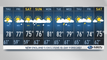
An area of high pressure is working its way over New England, yielding an overall pleasant day with lower humidity and temperatures compared to the first half of the week.
A disturbance pivoting south may bring an afternoon/evening sprinkle to some locations. Otherwise, high temperatures will rise into the upper 70s to low 80s across the lower elevations of the Connecticut River Valley and interior South Coast.
High pressure continues to work into New England overnight. Expecting a quiet night with lows dipping down into the 50s, 60s across the Cape and Islands, where cloudy skies decrease.
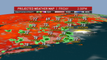
Friday features a dry start to the day before clouds move back in, bringing showers and a few storms to the region by the afternoon and evening. Highs reach into the mid to upper 70s with a few locations hitting 80 degrees.
Get Boston local news, weather forecasts, lifestyle and entertainment stories to your inbox. Sign up for NBC Boston’s newsletters.
Saturday is looking like a mostly dry day with a mix of clouds and sun. Can’t rule out the chance of a passing shower. Highs again will reach into the mid to upper 70s with a few lower elevations reaching 80 degrees.
Our stretch of pleasant weather comes to an end on Sunday as a disturbance and associated warm front approaches from the Great Lakes. Expecting showers and storms during the day on Sunday with a muggier feel to the air. Temperatures will hold fast in the mid to upper 70s given cloud cover and precipitation.
Winds will pick up throughout the day on Sunday, gusting to 20 MPH. A cold front moves through New England on Monday, leading to decreased chances of precipitation and a warm-up next week on the exclusive First Alert 10-Day forecast on NBC10 Boston and NECN.