Temperatures have dropped and we have a brisk wind around today from the northwest. You’ll need extra layers as you head out this afternoon, even with some sunshine in southern New England.
Highs only reach the 30s north, to 40s south. With the early 4:30(ish) sunsets, our temps fall quickly this evening to the upper 30s around dinnertime.
If you are brave enough to dine outdoors, make sure you are blocked from the wind and bundled up tight. Overnight lows drop to the 20s and 30s.
Get Boston local news, weather forecasts, lifestyle and entertainment stories to your inbox. Sign up for NBC Boston’s newsletters.
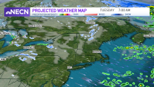
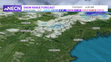
Snowfall will continue all day in the mountains, North Woods and the crown of Maine. Higher elevations will see 3-6” in snowfall, with less snow in lower elevations through Tuesday morning.
Snow squalls are possible too, if you are out driving up north. These are quick snow showers that reduce visibility to near zero, and set down quick accumulations.
Temps remain on the cooler side through Wednesday with highs in the 30s and 40s. Thursday, our temps are on the rise again with highs in the 60s. Colder air returns to for Friday.
In order for that to happen we will have a storm system Thursday into Friday. An area of low pressure tracks to our north, and will swing in scattered rain south and snow in the mountains. We dry off for the weekend with temps in the 40s.