We have a gorgeous start to the work week with high pressure in control. That means lots of sun. Our highs today will be in the 70s to low 80s with the classic sea breezes set up at the coast, keeping us cool and comfy there.
Another cool night is in store with lows in the 40s to 50s, so another stretch where we don’t need to run the air conditioning! Tuesday will be warmer, with highs in the 70s to 80s even at the coastline. The south coast will be cooler thanks to the gusty south wind.
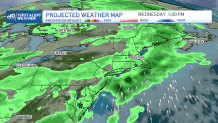
A system heads in for Tuesday into Wednesday. All we will notice on Tuesday is the increasing cloud cover along with the wind. Tuesday night into Wednesday we will see a few strong thunderstorms with gusty winds and heavy rainfall.
Get Boston local news, weather forecasts, lifestyle and entertainment stories to your inbox. Sign up for NBC Boston’s newsletters.
Another wave of rain moves through Thursday and this can give southern New England another great opportunity to pick up soaking rainfall…that hopefully helps the developing drought in eastern Massachusetts.
Friday we have a break from rainfall and highs will be in the mid 70s to low 80s with plenty of sun. This weekend brings us another wave of low pressure near the coast and heavy soaking rainfall. Highs will be in the 60s to 70s Saturday with gusty winds from the northeast.
The low pressure heads towards the Gulf of Maine Sunday, but stay tuned to the track and timing since this could certainly change at this point. All tolled, the system could bring 1-2" of rain by this time next week. Highs remain consistently mild throughout the rest of the 10-day.