
Hurricane Earl is growing larger, but it hasn't strengthened much — yet.
The storm sits 140 miles south of Bermuda with 100 mph winds. Friday, it's forecast to reach 120 mile an hour winds. Though the storm is nearly 1,000 miles away from the region, it will impact the waters of New England through the end of the week.
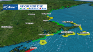
Swells from the distant hurricane are producing a moderate rip current risk along east-facing shores into the weekend. The risk is currently moderate along the coast of Nantucket. Friday, that risk is moderate for beaches along the North Shore, the arm of the Cape and the Islands. That risk extends to all of the Massachusetts coast on Saturday, with 6-to-8-foot seas along the Cape.
If you're caught in a rip, don't panic. If you're able to, swim parallel to the shore until you're out of the current.
Get Boston local news, weather forecasts, lifestyle and entertainment stories to your inbox. Sign up for NBC Boston’s newsletters.
Because the weather will be nice as summer wraps up this weekend, it will be pertinent for beachgoers to remain vigilant with hazards in the water.
More on Hurricane Earl


Along with Thursday evening's high tide, southern Fairfield County, Connecticut, may experience minor coastal flooding, with up to a foot of inundation above ground level in vulnerable areas near the waterfront.
With an eye roughly 50 miles wide, Earl is still pushing toward major hurricane status after it nears Bermuda. The storm is accelerating to the north-northeast and is set to bring tropical-storm force winds on the island Thursday night and Friday.
This weekend, an upper-level trough will capture Earl and bring a significant slow to the storm's forward motion. Earl will weaken steadily and become an extratropical low.
