
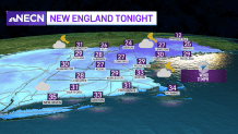
A sprinkle or flurry will still be found around southern New England, with a shower or light mix along the south coast, Cape and Islands Tuesday evening.
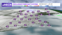
Most of us will stay dry. Northern New England will continue to see snow showers as a warm front lifts north Tuesday night. Light accumulation of a coating to 2 inches is expected in higher terrain through Wednesday morning.
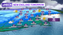
Our temperatures warm up a bit for Wednesday, with highs in the 40s, then highs in the low 50s in southern New England on Thursday as the wind also turns from the southwest.
Get Boston local news, weather forecasts, lifestyle and entertainment stories to your inbox. Sign up for NBC Boston’s newsletters.
A fast moving storm heads in Thursday though. Rain showers are expected for the morning south, while higher terrain and northern New England will see a mix and snow.
Sunshine returns for the afternoon, then we turn much colder as a cold front heads through by evening. A couple downpours move through and the wind increases a bit as temps fall to near freezing.
Colder air sticks around for Friday as the breeze adds to the chill. Highs only stay in the 30s both days this weekend.
Weather Stories


Saturday there is another potential wave of low pressure bringing in some light precipitation. Then the unsettled pattern continues next week as well with consistently colder air sticking around.
The active pattern also looks to remain in place through the 10-day outlook.
