Quite a volley of lightning with the storms that raced through the North Shore and Merrimack Valley last night. That was the cold front swinging through, and as its name suggests, today will be a bit cooler.

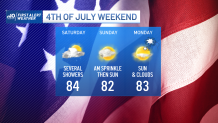
But I challenge you to tell the difference between yesterday and today. We’ll shave a mere one to three degrees off the high temperatures today. Sea breezes are still in play along the coast, but this is one of the best beach days of the week -- unless you count tomorrow’s searing heat.
Highs soar to the low 90s as we bake under a nearly full sun and a gusty southwest wind. The humidity won’t get an immediate jump on us, but eventually by evening the air will become soupy and sweaty.
Get Boston local news, weather forecasts, lifestyle and entertainment stories to your inbox. Sign up for NBC Boston’s newsletters.
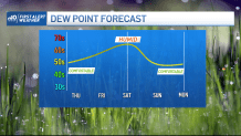
Humidity actually peaks Saturday as another cold front approaches. It’s this day that appears the wettest of the bunch. While not washed out entirely, it will feature a chance of showers both early and late (as of this typing). We could sneak in a few rays of sun, but I’m less optimistic about that.
Get updates on what's happening in Boston to your inbox. Sign up for our News Headlines newsletter.
Sunday sees a few sprinkles possible early on, then sun returns…along with warm temps. We’ll lower the humidity and sail into Independence Day with more sunshine and seasonable temperatures.
More unsettled weather could come towards the middle of next week. We’re still watching this for some beneficial rains. While not a total pattern shift, this could help put a dent in the drought. Fingers crossed…unless you’re on vacation.