
A huge upper atmospheric storm spiraling over the Great Lakes sent a bundle of atmospheric energy east into New England to focus heavy rain in association with an attendant surface cold front Monday night into Tuesday, dropping over an inch of rain for some and not even a quarter inch for others.
Highest rainfall amounts were distributed from central Massachusetts and the MetroWest points northeast into the Merrimack Valley and New Hampshire Seacoast, where many leaves were brought to the ground, creating slick roads, clogging storm drains for big puddles and ensuring some will have their first weekend of yard leaf cleanup this coming weekend.
The good news is the weather will be just fine for yardwork even long before the weekend begins. The same, large storm center that drove rain overhead has also grabbed a large chunk of dry air in its vast, counter-clockwise circulation and will deliver that dry air as soon as Tuesday afternoon with clouds breaking for emerging sun by day’s end, after morning rain breaks into showers, then slowly nudges east to end last on Cape Cod and in Maine Tuesday evening.
The new, dry air is cool, too – in fact, as cold air surged southward on the backside of the Great Lakes storm Monday night into Tuesday, a huge swath of chilly air surged into the Deep South of the U.S, with Tuesday night frost possible all the way into northern Louisiana and Mississippi, not to mention snow that fell in the Upper Great Lakes – 18 inches in Glen, Wisconsin!
Get Boston local news, weather forecasts, lifestyle and entertainment stories to your inbox. Sign up for NBC Boston’s newsletters.
Snowflakes won’t fly this time around in New England, but frosty conditions are possible overnight Tuesday night in sheltered valleys of central Massachusetts, northern Connecticut and interior southern New Hampshire, along with points farther north and west.
After high temperatures only in the 50s with sun Wednesday and a busy southwest wind particularly on Cape Cod, another chilly night Wednesday night should bring valley frost all the way to the Interstate 495 belt of eastern Massachusetts.
Weather Stories


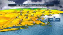
After one more brisk fall day Thursday with a notably busier breeze gusting to 30 mph from the southwest, Friday will bring a return of high temperatures near or over 60 degrees, and the weekend looks incredible – again. New England’s string of great fall weekends extends with Saturday and Sunday highs of 65-70 degrees, though Saturday will be sunnier than Sunday. Sunday’s increasing clouds eventually bring an extended chance of showers to our 10-day forecast, starting Monday and lasting through at least midweek next week.
