Quiet and beautiful weather has arrived in New England!
Dew points are much lower, in the 50s, and this means dry air has returned to the northeast. The next couple of days, we have a much-needed break from the humidity and the oppressive heat.
Boston had seven days in a row with 90 degrees or higher, tied for the sixth-longest heat wave on record. It's also the longest heat wave since 2013. The record stretch remains at nine days, in 1912.
The heat and humidity helped contribute to severe thunderstorms and a few tornadoes around New England during this most recent stretch.
Get Boston local news, weather forecasts, lifestyle and entertainment stories to your inbox. Sign up for NBC Boston’s newsletters.
But a cold front pushed through Monday night and now, here is the great weather!
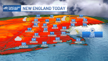
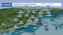
Highs Tuesday will be in the 70s to mid 80s with a nice westerly downsloping breeze. It’s time to give the AC a break with a crisp night as the air remains dry. Lows will drop to the low 60s south and to the 50s north.
High temperatures Wednesday will be just as comfy, again reaching the upper 70s to mid 80s. Thursday and Friday we have another system heading in, which means the humidity will creep up as temperatures reach the upper 80s.
If the humidity moves in early enough we will see some strong thunderstorms in the afternoon. Then the front seems to move through sometime Friday. The timing is still TBD, so stay tuned on the storm risks. Either way, we will see storms Thursday into Friday, higher humidity and highs nearing 90. The humidity lowers for the weekend as highs stay in the mid to upper 80s. We look dry both days! Some low 90s return for next week as the heat and humidity will build again.