
Showers are slowly spreading across southern New England this evening as temps hold in the 50s. Some downpours are possible this evening and heavier rainfall will become more widespread overnight.
Expect rain and snow with this system
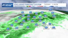
An area of low pressure develops south of us, and will ride across southern New England tonight. This helps to enhance our rainfall with about a quarter inch to half an inch of rain expected through tomorrow morning.
Get Boston local news, weather forecasts, lifestyle and entertainment stories to your inbox. Sign up for NBC Boston’s newsletters.
As the low pressure system settles around the Gulf of Maine and Nova Scotia the next few days, we continue to see clouds, cool temps, and some shower chances across eastern New England.
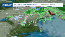
Thursday through Friday morning the far north country will see snow in higher terrain, and also for the crown of Maine. A couple inches of snow will be possible in Vermont and New Hampshire, to around half a foot in northern Maine.
Weather Stories


Winds ramp up midweek
Also as this storm stalls our wind increases. By tomorrow winds will be 30-40 mph from the northwest. And the gusty northwest wind continues through Thursday and Friday.
Chillier temps until the weekend
High temps will stay in the 50s and low 50s for this timeframe, with lows in the 30s. As this storms finally heads out by the weekend, we see our temperatures rebound to the mid 50s Saturday and fewer clouds from west to east. Sunday back in the 60s and these warmer temps remain for next week.
