The showers are upon us, but not everyone will get soaked today. It appears that northern Massachusetts and southern New Hampshire are on the very edge of this batch of rain, and will be spared a lot of the showers.
That said, a couple of lightweight sprinkles could roam through from time to time. The rest of the Commonwealth gets a healthy dose of rain.
It won’t stick around for the entire day, however. We will all see it taper to patchy mist and drizzle (yay?) in the afternoon and evening as this system swiftly moves away.
Sign up for our Breaking newsletter to get the most urgent news stories in your inbox.
Get Boston local news, weather forecasts, lifestyle and entertainment stories to your inbox. Sign up for NBC Boston’s newsletters.
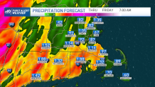
Thursday is spent in the clouds – mostly. Peeks of early sun are possible from time to time. We’ll wait until late night for round two of rain, and this could be a significant dose of water.
There may even be enough upper level energy to sprout a few thunderstorms late night. Between the two weather systems, this could push us over the one inch mark by Friday morning.
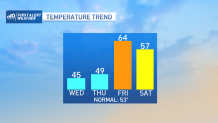
Speaking of, the sun should be shinning from the get-go, catapulting us through the low to mid 60s by afternoon. ‘Course, it’s not without the shower threat, so plan on some wet weather to pass through as well.
The weekend may still feature a quick shower to start on Saturday, but Sunday once again shines. Temps cool back to the 50s. We’re still on track for a major warmup next week. Big ridge of high pressure should boost us well into the 70s by the middle of the week!