That nasty storm system that’s been spreading wind damage, tornadoes, flooding and hail continues its rampage across the South. Last night it dropped a tornado in the heart of New Orleans. Then the same storm continued on toward Mobile, Alabama. We’re expecting another day of severe weather across Georgia and the Carolinas today.
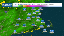
Here on the chillier side of the storm, there’s a chance of some wintry precipitation tonight. It may be brief, but it’s still enough to last for a couple of hours as it mixes with the first wave of rain.
Thereafter, we can expect a cold rain to fall into the morning hours. Most of the steady rain is expected in the early part of the day, then it should taper to mist and drizzle in the afternoon. There’s nothing about the day that’s dry…or warm.
Sign up for our Breaking newsletter to get the most urgent news stories in your inbox.
Get Boston local news, weather forecasts, lifestyle and entertainment stories to your inbox. Sign up for NBC Boston’s newsletters.
Today isn’t all that toasty either. As the clouds increase, the winds will turn in from the east – keeping us in the mid-40s at best. Some spots may be able to make the upper 40s or even 50 away from the coast.
Friday sees the sunshine return with a nice bounce back to near 60 in spots. While the weekend sees cooler temps, the chance for a spotty afternoon shower should remain squarely on Saturday’s shoulders as the final pocket of energy rotates around our departing storm. Wind will start back up on Sunday and carry into early next week.