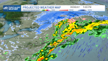
Low pressure will track across New England today, bringing another round of precipitation and gusty winds. For the most part, we’re expecting a rain event for the majority of the region. But along the Canadian border, we’ll likely be dealing with a wintry mix and snow, especially across northern Maine.
The precipitation moves in during the early morning hours across central and northern New England, but southern New England will remain mostly dry with the slight risk for showers through the mid-afternoon as much of the area remains south of the system’s warm front.
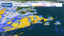
Rain will eventually develop from west to east later this afternoon and evening ahead of a cold front. Winds will also increase out of the southwest with gusts over 30-40 mph by the time we head into this evening. A few rumbles of thunder are also possible, but not expecting any severe storms to develop.
Sign up for our Breaking newsletter to get the most urgent news stories in your inbox.
Get Boston local news, weather forecasts, lifestyle and entertainment stories to your inbox. Sign up for NBC Boston’s newsletters.
Highs temperatures reach the mid to upper 50s south, near 60 southwest Connecticut, cooler south facing shorelines, including the Cape and Islands. North of the Massachusetts, New Hampshire and Vermont borders temps will be mostly in the 40s, 30s far north.
Precipitation ends late tonight from west to east as colder and drier air works into the region after the cold frontal passage. Winds will also continue to gust over 30 mph as winds switch more out of the west/northwest. Lows tonight drop into the mid to upper 30s south, upper 20s to 30 north.
As far as snowfall goes from this system, our exclusive inhouse model is forecasting a general 1-3” across the higher terrain of Vermont and New Hampshire, about 2-5” over northern Maine.
High pressure builds into the region Tuesday with cooler temperatures along with sunshine. We’ll still have to contend with a gusty northwest wind, which will make it feel colder than what it actually is. Highs mid 40s south, 30s north.
The rest of the week will feature slightly above average temperatures with the outside chance for snow showers along the south coast of New England Wednesday night into early Thursday as a wave of low pressure passes to our south.
A widespread event is possible by the weekend, which looks to be mostly rain as we find ourselves on the mild sector of the system. Still some uncertainty in that storm’s exact track and timing, so we will likely need to fine tune that portion of our 10-Day Forecast. Stay tuned!