
Ian’s remnants keep spinning south of us, keeping the rain and wind in the forecast. Because the low pressure is so close to the high pressure just north of us, gusty northeast winds persist through Wednesday. Gusting at 20-35 miles per hour, Barnstable, Plymouth and Bristol Counties, as well as the islands, continue to see most of the wind action. The wind chill goes down closer to 50 today and the rain is slowly spreading north up to southern New Hampshire and Portland Maine tomorrow. Rainfall amounts may add up close to an inch in the southeast and up to half an inch across western Massachusetts.
Seas continue to build and reach up to 10 feet high Tuesday, 8 feet high Wednesday and 5 feet high by Thursday. High tide is taking place around 7 p.m. Small craft advisories remain in effect across the eastern seaboard and Gale warnings across the south facing beaches that stretch from Virginia up to Nantucket.
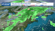
Now to better and warmer news, temperatures will rise Thursday and Friday and reach the 70s. The driest day will be Thursday, as Friday welcomes our next frontal boundary that will push in the chance for showers entering Vermont and the north, pushing into central New England by the evening hours.
Get Boston local news, weather forecasts, lifestyle and entertainment stories to your inbox. Sign up for NBC Boston’s newsletters.
A high pressure comes to take control on Sunday, for which our weekend pattern is looking mostly sunny but cool. Highs on Saturday will remain in the mid-60s, but Sunday features near 60 by the afternoon.
